Editorial: Yedoma Permafrost Landscapes as past Archives, Present and Future Change Areas
 Lutz Schirrmeister1*
  Alexander N. Fedorov2
  Duane Froese3
  Go Iwahana4
  Ko van Huissteden5
  Alexandra Veremeeva6
- 1Alfred Wegener Institute Helmholtz Centre for Polar and Marine Research (AWI), Permafrost Research Section, Potsdam, Germany
- 2Melnikov Permafrost Institute, Siberian Branch of the Russian Academy of Sciences (RAS), Yakutsk, Russia
- 3Department of Earth and Atmospheric Sciences, University of Alberta, Edmonton, AB, Canada
- 4International Arctic Research Center, University of Alaska Fairbanks, Fairbanks, AK, United States
- 5Faculty of Science, Earth and Climate, Vrje Universiteit Amsterdam, Amsterdam, Netherlands
- 6Institute of Physical-Chemical and Biological Problems in Soil Science (RAS), Pushchino, Russia
Editorial on the Research Topic
Yedoma permafrost landscapes as past archives, present and future change areas
Introduction
Yedoma Ice Complex (IC) ice-rich fine-grained permafrost deposits formed during the Marine Isotope Stages 4 to 2 covered several million km2 of the Arctic mainland. The Yedoma domain spanns from the Taymyr Peninsula in the west to the Yukon of Northwest Canada, and from Central Yakutia in the south to the Arctic shelves in the north. Today about 2.6 million km2 in Siberia, Alaska and Northwest Canada are considered to contain remnants of the Yedoma IC deposits (Strauss et al.) and thus belong to the Yedoma domain. The cold and dry (continental) climate conditions that were common across these areas define common depositional features such as prevalence of widespread fine-grained sediments, large syngenetic polygonal ice wedges and other specific ground ice types. These occur along with large quantities of buried, well-preserved organic matter, and fossil remains of the mammoth megafauna and other tundra-steppe faunal and floral fossils. The once extensive periglacial landscapes of the Yedoma domain are synonymous with Ice Age Beringia, and developed over tens of millennia in unglaciated regions where late Pleistocene syngenetic permafrost aggraded and later underwent widespread degradation during the Lateglacial and early-Holocene warming. This last period of rapid thaw transformed the Yedoma domain from tundra-steppe polygonal tundra into a lake-rich thermokarst landscape across the poorly drained lowlands. At the same time, vast shares of the continental Arctic shelf were flooded by the postglacial transgression of Arctic seas. Ice-rich Yedoma deposits were and still are vulnerable to climate warming, leading to diverse landscape responses such as deepening of the active layer, surface subsidence, thermokarst, thermo-erosion, as well as remobilization of increasingly vulnerable long-buried organic matter and the subsequent release of greenhouse gases.
In the present Research Topic on Yedoma permafrost landscape, the study regions comprise areas at the Kara Sea coast, coasts of the Laptev and East Siberian seas and in their hinterland in the Yana- Indigirka and Kolyma lowlands, in Central Yakutia, as well as at the Alaskan Chukchi Sea coast, in the Brooks Range foothills, and in Central Alaska (Figure 1). The entire study region in this Research Topic covers a wide area between 66.8°E (Marre Sale Polar Station, Yamal Peninsula) and -147.7°E (Vault Creek Tunnel, Fairbanks) and between 61.76°N (Tabaga, Central Yakutia) and 76.17°N (Cape Anisii, Kotelny Island).
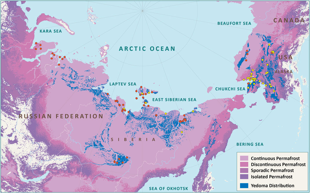
FIGURE 1. Distribution of Yedoma Research Topic study sites. Red circles—single sites that are subject of the various papers in the Research Topic; Yellow circles—locations of the historical observations according to Shur et al. (Map by Sebastian Laboor, AWI).
OVERVIEW INFORMATION
The topics of the present article collection cover a wide range of scientific approaches and research interest.
Yedoma Research History and Distribution
The history of Yedoma research from its beginning in the early 19th century to the mid-20th century is presented by a review paper of Shur et al. A detailed digital map of the pan-Arctic Yedoma domain is presented by Strauss et al. This domain covers 2,587,000 km2 of the Arctic and sub-Arctic and Yedoma deposits are found within 480,000 km2 of this region.
Paleo-Ecological, Geochronological, Cryolithological, and Archaeological Studies
A large number of site-specific results are presented on paleo-ecological, geochronological, and cryolithological characteristics of Yedoma deposits and also include some archaeological findings. From Western Siberia, Streletskaya et al. conclude, that the formation of ice-rich permafrost on the Kara Sea coast occurred in two stages, i.e., as marine stage with characteristic marine and coastal conditions (Marine Isotope Stage (MIS) 5—MIS 3) and as continental stage (MIS 3—MIS 2).
From the Sobo-Sise Island in the Lena River Delta, Wetterich et al. present paleoecological results of pollen, chironomid, diatom, and mammal bone studies. The records confirm the existence of tundra-steppe environments during MIS 3 with partly warmer-than-today summers and wetter conditions allowing for stagnant water (i.e., polygon ponds). During MIS 2, summers were colder and drier but shallow polygonal ponds were suitable for maintaining chironomid fauna.
Almost 2000 fossil bones of the Mammoth fauna were studied by Kuznetsova et al. at the southern coast of the Dmitry Laptev Strait. The collection consists of 13 mammal species with prevalent woolly mammoth (40.5%), bison (19%), horse (18.8%), reindeer (15.8%), and rare findings of woolly rhinoceros, saiga antelope, elk, moose, cave lion and wolf (each <1%). Tumskoy and Kuznetsova conclude that the cryostratigraphical subdivisions identified on both sides of the Dmitry Laptev Strait are identical and allow for reconstructing the regional geological development from the end of the middle Pleistocene to the present.
Extensive geological observations and site descriptions of the Yana Rhinoceros Horn Site (Yana RHS) in the course of archaeological excavations are presented by Pitulko and Pavlova from the lower Yana River. The culture-bearing horizon reflects that several human habitation episodes took place here during the late MIS3.
Results of cryogenic weathering from exposures at the lower Kolyma River by Shmelev et al. emphasize that polygenetic Yedoma deposits were affected by post-depositional processes, mainly by cryogenic weathering. Holocene warming caused thawing of the upper part of the Yedoma deposits and re-deposition, but also intensified cryogenesis due to more frequent freeze-thaw cycles.
The plant macrofossil assemblage from an exposure near Cherskiy (Kienast and Davydov) reveals the predominance of grassland vegetation composed of tundra steppes, meadow steppes and saline meadows in this area during the late early to early middle Pleistocene (Early Olyorian).
From Central Yakutia north of Yakutsk, Hughes-Allan et al. present a high-resolution record of a sediment core which spans the Pleistocene-Holocene transition and encompasses the continuous Holocene time series. There was considerable variation in biogeochemical proxies both between and within three stratigraphic units.
From Alaska, Kanevskiy et al. present new cryostratigraphical data of the recently excavated sections of the CRREL Permafrost Tunnel near Fairbanks. They provide new opportunities to study the structure, properties and biogeochemical characteristics of Yedoma deposits to deduce the deposition history. The study shows differences from earlier permafrost tunnel investigations in that an earlier thaw unconformity was not prominent. The study underscores the complexity in correlating between Yedoma deposits, even over short distances, but also the need to replicate observations of Yedoma formation across regions and through detailed cryostratigraphy and dating.
Mineralogical, Geochemical and Organic Matter Studies Including the Greenhouse Gas Potential
A new method combination (portable X-ray fluorescence (pXRF) with a bootstrapping technique) is introduced by Monhoval et al. 1) in a method paper that generated the first mineral element inventory of permafrost deposits from the ice-rich Yedoma region. In the resulting Yedoma domain Mineral Concentrations Assessment (YMCA) dataset, the total concentrations of 10 mineral elements (Si, Al, Fe, Ca, K, Ti, Mn, Zn, Sr, and Zr) in Yedoma domain deposits have been quantified in 75 different profiles. In a second paper (Monhoval et al. 2), the iron redistribution upon thermokarst processes in the Yedoma domain is considered. A key conclusion is that changes from frozen to unfrozen state leads to modifications of multiple environmental conditions (fluctuating redox conditions, subsidence, leaching, and drainage) with indirect impact on Fe-oxides distribution and hence on a portion of mineral-protected organic carbon pools.
In Central Yakutia, Ulrich et al. explores geochemistry and weathering indices of Yedoma and Alas deposits beneath thermokarst lakes. The geochemical and sedimentological properties of Yedoma IC deposits are traceable in talik and frozen deposits below thermokarst lakes as they differ from lacustrine thermokarst deposits.
A first deep mercury inventory of late Pleistocene permafrost deposits down to 36 m depth below surface compares two sites in Central Yakutia and on Bykovsky Peninsula (Laptev Sea) in a study by Rutkowki et al. Increasing thermokarst processes and coastal erosion in Arctic permafrost regions will liberate the available Hg and very likely enable the increase of highly toxic CH3Hg+ in the terrestrial ecosystem, the Arctic Ocean, and the food chains of both realms.
Types and micromorphology of authigenic carbonates in Yedoma IC deposits at the lower Kolyma were studied by Rogov et al. These deposits contain authigenic carbonates of several generations: polymorphic (calcite and aragonite) and isomorphic (manganocalcite, rhodochrosite, and siderite) calcium carbonates and complex Fe-Al compounds.
An aerobic long-term incubation experiment was conducted over a course of 1.5 years (Melchert et al.) to study sources of CO2 produced in freshly thawed Yedoma deposits from the Lena River Delta. Dual carbon isotopic source assessment revealed that large proportions of up to 80% ancient organic and about 18% inorganic carbon were likely released from these deposits. The pool of young organic matter was preferentially respired in microbial consumption. The contribution of ancient carbon sources, both organic and inorganic, to the CO2 may further increase (by about 6–7%) upon longer thaw as indicated at the end of the aerobic incubation at 4°C after 1.5 years.
Heavy and light mineral associations from 18 permafrost sites in the northern Siberian Arctic were studied by Schirrmeister et al. The records suggest mostly local sediment sources and highlight the role of sediment reworking under periglacial regimes through time, including for example the formation of Holocene thermokarst and thermo-erosional deposits sourced by remobilized Yedoma IC deposits.
Studies of dissolved organic carbon (DOC) from permafrost deposits are a fairly new permafrost research topic. Stolpmann et al. analyze in the Lena River Delta the influence of lakes and ponds, interposed in a stream catchment, on DOC concentrations and export. They found decreasing DOC concentration from a thermokarst lake via a stream to a river channel. The data also indicate that old Yedoma and Holocene carbon might be mobilized into thermokarst lake systems. Under future climate, degrading Yedoma permafrost will cause changes in groundwater and subsurface flow in Arctic watersheds and may increase DOC export. Lakes and ponds may act as DOC filters by diluting incoming waters of higher DOC concentrations and modifying DOC to CO2 and CH4.
Biogeochemical Inventories and Microbiology
Biogeochemical inventories and trajectories in permafrost soils are considered by Desyatkin et al. who studied the degradation of arable soils in Central Yakutia and the negative consequences of global warming for Yedoma landscapes. The abandonment of croplands under the conditions of the recent continuous warming of the climate does not result in the restoration of the initial landscape but strengthens negative impacts on soils. As a result of thermokarst, the development of microtopography, and downward shift of the permafrost table, the morphology of soils is reconstructed with a change in their classification position. The cryosols are transformed into Solonets and eroded Cambisol types, and the large spatial contrast in soil properties, such as pH, bulk density, and organic carbon content, appears in the soil profiles.
One paper in our collection deals with microbiological studies of permafrost deposits in Central Yakutia. Cherbunina et al. suggest that two Ice Complex horizons differ in water origin of wedge ice and in their cryogenic evolution, evidenced by differences in chemistry, water isotopic signatures, and microbial community compositions. Microbial community similarity between ground ice and host deposits is shown to be a proxy for syngenetic deposition and freezing. They show a high degree of community similarity consistent with syngenetic formation of ice wedges and host deposits. As well, they found a correspondence between the origin of the water and degree of evaporative transformation in ice wedges with the microbial community composition.
Under the topic studies of modern and future environmental changes Park et al. investigate the impacts of excess ice on permafrost, soil water dynamics, and CO2 and CH4 fluxes in a Siberian tundra site under the strong future emission scenarios. The model results indicate that the warming air temperature and higher snow depth were major factors driving active layer thickness increases and permafrost degradation. In contrast, the presence of a moss layer and large excess ice content stabilize permafrost.
Remote Sensing and Geophysical Studies of Landscape Changes
Geophysical investigation of permafrost underground using 3D ground penetrating radar observations was performed by Schennen et al. at the same study area on Bol’shoy Lyakhovsky Island (New Siberian Archipelago) to point out advantages and disadvantages for deducing subsurface permafrost properties under completely frozen (springtime) and superficially thawed (summertime) conditions. When comparing selected reflections recorded in summer and spring, the spring data show a higher dynamic range in amplitudes and a higher vertical resolution, resulting in a generally sharper image of subsurface structures. In contrast, summer images provide a lower dynamic range and lower vertical resolution resulting in a smoother image of subsurface structures. This might ease reflector tracing and picking, but hinders a detailed imaging and interpretation as using the spring data.
Yedoma IC remnants usually are presented by positive relief forms - Yedoma uplands. Due to the high ice content up to 90% they are susceptible to vertical surface displacements by thaw and refreeze of ground ice in the upper permafrost layer and permafrost degradation due to thermokarst, thermoerosion, and thermodenudation. Huissteden et al. explore the relation between a data set from 2017 to 2019 of InSAR measurements of vertical surface displacements during the thaw season, and geomorphological features at a site in the Yana-Indigirka Lowland. Distinct spatial clusters of displacement trajectories can be discerned, which relate to geomorphological processes and ground ice conditions. Strong subsidence occurred in particular in 2019. In the wet year of 2017, marked heave occurred at Yedoma plateau surfaces, likely by ice accumulation at the top of the permafrost driven by excess precipitation.
Teshebaeva et al. investigate permafrost dynamics and degradation on the Yamal Peninsula from satellite radar observations. Surface relief dynamic analysis shows about 2 m net loss of surface topography over 14 years (2000–2014) associated with active discharge of water and sediments. In addition, InSAR time-series analysis shows active subsidence for the time period from 2017 to 2018 in three distinct spatial locations. The observed three locations show rates from 60 up to 120 mm/yr of seasonal surface changes.
Iijima et al. evaluated the distribution of topographic subsidence caused by thermokarst development in Central Yakutia. The results of InSAR stacking analysis show that the interannual trend of surface subsidence by thawing permafrost of Yedoma IC mainly occurred in deforested areas and agricultural fields. The thermokarst development in Central Yakutia has progressed since the 2000s. InSAR analysis using the ALOS series of satellites can detect topographic changes over the years. By comparing with digital surface models and high-resolution images from unmanned aerial systems, which have a resolution of the order of less than 10 cm, we can effectively examine the development of thermokarst in the area where the InSAR displacement appeared.
Conclusion
Papers written in this Yedoma Research Topic represent a broad view on the current state of knowledge in permafrost research with respect to unique Yedoma domain landscapes in the past, present, and future. Research in this field has been conducted for many decades, and still remains active and important. The main topics are understanding the formation and transformation of Yedoma IC deposits based on paleo-environment records, present Yedoma landscape dynamics, and their future response to climate change. The Yedoma domain once covered vast areas of the terrestrial Arctic and still stores large amounts of buried carbon some of which likely will be mobilized under ongoing and future warming. Understanding the formation and storage of organic matter preserved in Yedoma deposits requires paleoenvironmental research to estimate the extrinsic (climate) and intrinsic (periglacial processes) controls on permafrost aggradation and degradation. The 26 studies in this Research Topic originate from an international group of authors highlight the common interest in this particularly important type of permafrost and the potential of Yedoma research as a scientific bridge between different disciplines and various national scientific communities.
This paper collection is the final activity of the International Permafrost Association (IPA) action group “The Yedoma Region: A Synthesis of Circum-Arctic Distribution and Thickness”.
Author Contributions
LS has drafted the text and all other authors have contributed with their own suggestions.
Conflict of Interest
The authors declare that the research was conducted in the absence of any commercial or financial relationships that could be construed as a potential conflict of interest.
Publisher’s Note
All claims expressed in this article are solely those of the authors and do not necessarily represent those of their affiliated organizations, or those of the publisher, the editors and the reviewers. Any product that may be evaluated in this article, or claim that may be made by its manufacturer, is not guaranteed or endorsed by the publisher.
Keywords: Yedoma Ice Complex, circum Arctic, nonglaciated Beringia, environmental changes, late Pleistocene to Holocene
Citation: Schirrmeister L, Fedorov AN, Froese D, Iwahana G, van Huissteden K and Veremeeva A (2022) Editorial: Yedoma Permafrost Landscapes as past Archives, Present and Future Change Areas. Front. Earth Sci. 10:929873. doi: 10.3389/feart.2022.929873
Received: 27 April 2022; Accepted: 11 May 2022;
Published: 07 June 2022.
Edited and reviewed by:
Michael Lehning, Swiss Federal Institute of Technology Lausanne, SwitzerlandCopyright © 2022 Schirrmeister, Fedorov, Froese, Iwahana, van Huissteden and Veremeeva. This is an open-access article distributed under the terms of the Creative Commons Attribution License (CC BY). The use, distribution or reproduction in other forums is permitted, provided the original author(s) and the copyright owner(s) are credited and that the original publication in this journal is cited, in accordance with accepted academic practice. No use, distribution or reproduction is permitted which does not comply with these terms.
*Correspondence: Lutz Schirrmeister, Lutz.Schirrmeister@awi.de