


Ku, Teh-Lung; Omura, Akiko; Chen, P S (1972): (Table 4, page 800) U, Th and Pa analyses for the top layers of a ferromanganese crust of the Pacific Ocean (Mn139) [dataset]. PANGAEA, https://doi.org/10.1594/PANGAEA.867562, In supplement to: Ku, T-L et al. (1979): Be10 and U-series isotopes in manganese from the Central North Pacific. In: Bischoff, J.L., Piper, D.Z. (Eds.), Marine Geology and Oceanography of the Pacific Manganese Nodule Province. Marine Science, Plenum Publishing Corporation, New York, U.S.A., 791-814, https://doi.org/10.1007/978-1-4684-3518-4_26
Always quote citation above when using data! You can download the citation in several formats below.
Published: 1972 (exact date unknown) • DOI registered: 2016-12-04
Project(s):
Coverage:
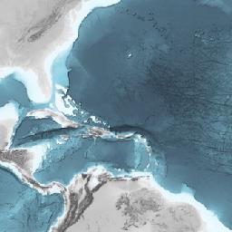
Latitude: 20.016667 * Longitude: -136.600000
Date/Time Start: 1976-11-15T00:00:00 * Date/Time End: 1976-11-15T00:00:00
Minimum Elevation: -3916.0 m * Maximum Elevation: -3916.0 m
Event(s):
L1076HW-9A * Latitude: 20.016667 * Longitude: -136.600000 * Date/Time: 1976-11-15T00:00:00 * Elevation: -3916.0 m * Location: Pacific Ocean * Campaign: L-10-76-HW * Basis: Samuel P. Lee * Method/Device: Dredge (DRG)
Comment:
Uranium, Thorium and Palladium measurements were done using an alpha-spectrometry technique described in : Ku, T.L., Broecker, W.S., 1969. Radiochemical studies on manganese nodules of deep-sea origin. Deep Sea Research and Oceanographic Abstracts 16, 625-637.
From 1983 until 1989 NOAA-NCEI compiled the NOAA-MMS Marine Minerals Geochemical Database from journal articles, technical reports and unpublished sources from other institutions. At the time it was the most extended data compilation on ferromanganese deposits world wide. Initially published in a proprietary format incompatible with present day standards it was jointly decided by AWI and NOAA to transcribe this legacy data into PANGAEA. This transfer is augmented by a careful checking of the original sources when available and the encoding of ancillary information (sample description, method of analysis..) not present in the NOAA-MMS database.
Parameter(s):
| # | Name | Short Name | Unit | Principal Investigator | Method/Device | Comment |
|---|---|---|---|---|---|---|
| 1 | Identification | ID | Ku, Teh-Lung | |||
| 2 | DEPTH, sediment/rock | Depth sed | m | Ku, Teh-Lung | Geocode | |
| 3 | DISTANCE | Distance | cm | Ku, Teh-Lung | Geocode | |
| 4 | Distance, minimum | Dist min | mm | Ku, Teh-Lung | ||
| 5 | Distance, maximum | Dist max | mm | Ku, Teh-Lung | ||
| 6 | Uranium-238 | 238U | dpm/g | Ku, Teh-Lung | ||
| 7 | Uranium-238, standard deviation | 238U std dev | ± | Ku, Teh-Lung | ||
| 8 | Thorium-232 | 232Th | dpm/g | Ku, Teh-Lung | Alpha spectrometry | |
| 9 | Thorium-232, standard deviation | 232Th std dev | ± | Ku, Teh-Lung | ||
| 10 | Uranium-234/Uranium-238 activity ratio | (234U/238U) | Ku, Teh-Lung | |||
| 11 | Uranium-234/Uranium-238 activity ratio, standard deviation | (234U/238U) std dev | ± | Ku, Teh-Lung | ||
| 12 | Thorium-230 excess | 230Th xs | dpm/g | Ku, Teh-Lung | ||
| 13 | Thorium-230 excess, standard deviation | 230Th xs std dev | ± | Ku, Teh-Lung | ||
| 14 | Protactinium-231 excess | 231Pa xs | dpm/g | Ku, Teh-Lung | ||
| 15 | Protactinium-231 excess, standard deviation | 231Pa xs std dev | ± | Ku, Teh-Lung | ||
| 16 | Deposit type | Deposit type | Ku, Teh-Lung | |||
| 17 | Description | Description | Ku, Teh-Lung |
License:
Creative Commons Attribution 3.0 Unported (CC-BY-3.0)
Size:
88 data points
Download Data
Datasets with similar metadata
- Friedrich, G; Schmitz-Wiechowski, A (2022): Chemical analysis of various layers forming a ferromanganese crust retrieved in the Pacific Ocean (VA 13/2 - 237KD). https://doi.org/10.1594/PANGAEA.952336
- Reyss, J-L; Lemaitre, N; Ku, T-L et al. (2022): U-Th isotopes and Fe-Mn composition of layers from the top side of Mn nodule SO11_262DK (262GBHF). https://doi.org/10.1594/PANGAEA.943683
- Bolton, BR; Ostwald, J; Monzier, M (1986): (Table 1, Page 518) Bulk chemical composition of a ferromanganese crusts from the South-West Pacific. https://doi.org/10.1594/PANGAEA.862079